Bolivia
La Paz
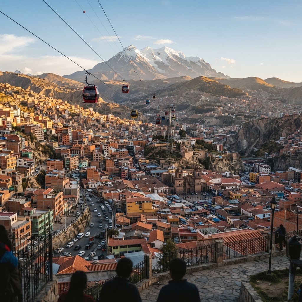
A sprawling Andean canyon city navigated by aerial cable cars beneath snowcapped Illimani.
Plan & book
Sort your La Paz trip in one place.
We point you to the booking tools we'd actually use — live prices, no markup. Or let us build the day-by-day plan around you first, then book.
Set inside a dramatic 3,600-meter canyon with Mount Illimani towering on the horizon, La Paz is a high-altitude collision of indigenous Aymara traditions and rapid modern transit. It is defined less by polished museum corridors and more by vertical geography: hundreds of red brick neighborhoods spill down precipitous ridges, stitched together by the world's most extensive urban cable car network. For travelers willing to acclimate, it offers raw cultural energy, a blossoming native gastronomy scene, and a pace found nowhere else in South America.
3 to 4 days
Best time
May to September for crisp mountain visibility, minimal rainfall, and dependable transit across the Andes.
Build your own trip with these prebuilt itineraries
Each one is a tested, day-by-day plan for La Paz — start here, then make it yours.
4 Days in La Paz: High-Altitude Adventure in La Paz
Adrenaline-fueled adventures combining city exploration with classic day treks and biking trips in the surrounding Andes
3 Days in La Paz: Highlights & Cable Cars in La Paz
Essential cultural highlights, acclimatization pacing, and aerial sightseeing via the iconic Mi Teleférico network
2 Days in La Paz: Andean Cuisine & Culture in La Paz
A compressed, food-forward focus highlighting world-class New Andean fine dining, markets, and indigenous traditions
To witness an Andean metropolis engineered vertically rather than horizontally. Instead of sitting in exhaust-choked traffic on impossibly steep cobblestone hills, you fly over neighborhoods on Mi Teleférico for less than fifty cents. Between centuries-old ritual herbalists at the Witches' Market, preserved colonial streets like Calle Jaén, and hyper-local fine dining built on native altiplano crops, La Paz rewards travelers seeking grit, culture, and sensory overload.
Where to stay
Getting there
Getting around
Food & drink
What it costs
Things to do
Book tours & tickets in La PazSkip it if
Skip La Paz if you suffer from serious respiratory or cardiovascular conditions that make spending multiple days above 3,600 meters dangerous. It is also not suited for travelers demanding pristine Swiss-level public order, manicured pedestrian promenades, or leisurely strolls without steep grade changes.
When to go
The dry Andean winter guarantees bright blue skies that showcase Mount Illimani and keep cable-car routes operating smoothly, but night temperatures frequently dip near freezing. The trade-off is higher demand for Altiplano tours and freezing night winds.
Peak (May to September)
Dry, clear, and sunny by day, but bitterly cold after sundown. Prime conditions for Cordillera Real trekking and road transit, though hotel heating becomes essential.
Shoulder (April & October to November)
Mild daytime temperatures with fewer tour crowds. Mornings are generally clear with isolated afternoon rain; great balance of value and manageable weather.
Low (December to March)
Wet summer season. Heavy downpours lead to mudslides along canyon roads and frequent delays for buses heading to Coroico or Lake Titicaca.
Neighborhoods
Where you stay shapes the trip. Here's how to think about it.
Sopocachi
Bohemian, leafy, and pedestrian-friendly enclave of cafes, embassies, and craft beer bars set on gentler slopes.
Best for:independent travelers, food lovers, and long stays
Don't miss:Coffee and fresh pastries at Typica Café before catching sunset views over the canyon from Mirador Montículo.
Casco Urbano Central / Historic Center
High-intensity street commerce, congested colonial avenues, and pervasive scent of copal incense.
Best for:first-timers and culture seekers who want walking access to historic sites
Don't miss:Browsing traditional ritual supplies, dried llama fetuses, and herbal remedies along Calle Linares and Calle Jiménez in the Witches' Market.
Zona Sur (Calacoto & San Miguel)
Upscale, manicured, and distinctly warmer valley district with contemporary boutiques and modern high-rises.
Best for:families, luxury seekers, and travelers struggling with altitude acclimatization
Don't miss:The innovative multi-course Bolivian tasting menu at Gustu along Avenida Costanera.
El Alto (Cliff Edge & 16 de Julio)
Raw, vast Altiplano metropolis defined by vibrant Neo-Andean Cholet architecture and immense indigenous markets.
Best for:architecture enthusiasts, adventure travelers, and experienced cultural explorers
Don't miss:Taking the Mi Teleférico Línea Roja or Plateada to view Freddy Mamani's candy-colored Cholet mansions and the sprawling Thursday/Sunday 16 de Julio market.
Miraflores
Orderly, practical middle-class residential district home to major hospitals, university grounds, and local comedores.
Best for:remote workers and long-term travelers wanting a calm, nontouristy base
Don't miss:The replica subterranean temple and Tiwanaku stone monoliths inside the open-air Plaza Arqueológica (Plaza del Stadium).
Destination intelligence
Updated 9/14/2026The structured record we plan every La Paz itinerary from.
Walkability
Moderate within flat pockets like Sopocachi or parts of Zona Sur, but generally strenuous due to relentless steep grades, thin air, and uneven sidewalk curbs.
Transit quality
Exceptional via the Mi Teleférico cable car system; ground transit is slow and congested.
Car needed
Not recommended. Rental cars are a liability due to steep topography, aggressive driving habits, and an aerial transit network that renders driving obsolete.
Ideal duration
3 to 4 days
Minimum useful
2 days
Peak season
May to September (the dry Andean winter brings crisp blue skies, freezing nights, and the best trekking/cable-car visibility).
Shoulder season
April and October to November (mild temperatures, fewer tour groups, and mostly clear mornings before occasional afternoon showers).
Low season
December to March (the wet summer season; heavy rains lead to frequent landslides in canyon roads and delayed regional buses).
Best for
Common mistakes
- Treating Day 1 like a normal sightseeing day instead of scheduling mandatory rest, hydration, and light meals to adjust to 3,600+ meters.
- Renting a rental car; traffic is chaotic, streets are steep, narrow, and parking is nearly impossible compared to riding Mi Teleférico.
- Hailing unmarked street cabs after dark instead of booking pre-arranged radio taxis or hotel transfers to prevent express kidnapping scams.
- Planning tight same-day transport connections without buffer time for frequent highway blockades or transport strikes.
Best nearby
See what a trip to Bolivia actually costs. Travel Budget Co.
How to plan it
- Base yourself in Zona Sur (Calacoto) for your first 48 hours if you are sensitive to thin air; its 3,200-meter floor gives you 400 to 800 vertical meters of altitude relief over the center and airport.
- Ride the Mi Teleférico circuit (combining Línea Roja, Plateada, and Amarilla) midday for unmatched city views without exerting yourself on steep canyon staircases.
- Don't stack a dawn arrival at El Alto airport with an afternoon mountain bike ride down the Yungas Road; give yourself two full sleep cycles before undertaking heavy cardio excursions.
- Pair La Paz with an overland journey onward to Lake Titicaca (Copacabana) or a 45-minute flight to the Salar de Uyuni; it acts as the cultural and transit hinge of western Bolivia.
- Book high-end tasting menus at Gustu at least two weeks before traveling, but leave lunch open for unscripted mid-morning salteñas at neighborhood bakeries like Paceña La Salteña.
Questions
Readymade itineraries
Start from a tested template — then make it yours.
Ready to book
Lock in your La Paz trip
Everything in one place. We may earn a small commission — it never costs you more.
Plan a trip to La Paz
Pick a length and we'll build a day-by-day plan around how you travel — neighborhoods clustered, budget-aware, and editable.
Get better at planning trips like this
Occasional notes on planning smarter — no spam, unsubscribe anytime.
Plan a trip to La Paz
Turn this guide into a day-by-day plan built around your pace, your group, and your budget.
Build my La Paz trip